")
")


The LSD&D (Land Surface Dynamics and Degradation) Laboratory is devoted to the study of complex phenomena involving land cover and its changes caused by to anthropic and natural drivers (land degradation, urban expansion, climate change, etc.).
Earth Observation techniques represent the main observational basis (together with environmental and socioeconomic ancillary variables) used in the laboratory to investigate those dynamic processes occurring at the interface between the earth and the atmosphere and influencing crop health conditions, carbon balance, sustainability of natural resources exploitation, etc.. The genesis of these processes and their ecological-environmental impacts are studied both in terms of basic research and to support a wide range of environmental policies concerning soil, forests, ecosystems and biodiversity.
The LSD&D laboratory covers the entire chain of remote sensing data processing, in particular multi and hyperspectral data: from the pre-processing of raw information to the fine-tuning of synthetic products for different end-users (e.g., Public Administrations) through the use of innovative procedures of multiparametric and multi-resolution statistical analysis.
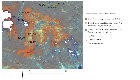
Fig. 1: Example of synthetic products obtained from the combined use of remote sensing data (in this case from the Sentinel 2 satellite with a spatial resolution of 10m) and ancillary parameters (altitude) to identify areas affected by a late frost events in mountain environments (Extreme Weather Event – EWE).
This email address is being protected from spambots. You need JavaScript enabled to view it.